Afrin District
This article is about the dejure district. For the defacto canton, see Afrin Canton.
| Afrin District منطقة عفرين | |
|---|---|
| District | |
 Location of Afrin District within Aleppo Governorate | |
| Coordinates (Afrin): 36°30′36″N 36°52′04″E / 36.51°N 36.8678°ECoordinates: 36°30′36″N 36°52′04″E / 36.51°N 36.8678°E | |
| Country |
|
| Governorate | Aleppo |
| Seat | Afrin |
| Subdistricts | 7 nawāḥī |
| Area | |
| • Total | 1,840.85 km2 (710.76 sq mi) |
| Population (2004)[1] | 172,095 |
| Geocode | SY0203 |
Afrin District (Arabic: منطقة عفرين, translit. manṭiqat Afrīn; Kurdish: Efrîn) is a district of Aleppo Governorate in northern Syria. Administrative centre is the city of Afrin. At the 2004 census, the district had a population of 172,095.[1]
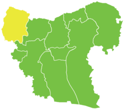
The administrative center of Nahiya Afrin shown above is the city of Afrin.

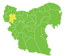
The administrative center of Nahiya Jindires shown above is the city of Jindires.
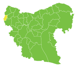
The administrative center of Nahiya Shaykh al-Hadid shown above is the city of Shaykh al-Hadid.

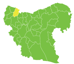
The administrative center of Nahiya Maabatli shown above is the city of Maabatli.
The administrative center of Nahiya Sharran shown above is the city of Sharran.

The administrative center of Nahiya Bulbul shown above is the city of Bulbul.

The administrative center of Nahiya Rajo shown above is the city of Rajo.
Sub-districts
The district of Afrin is divided into seven sub-districts or nawāḥī (population as of 2004[1]):
| Code | Name | Area | Population | Seat |
|---|---|---|---|---|
| SY020300 | Afrin Nahiya | 427.73 km² | 66,188 | Afrin |
| SY020301 | Bulbul Nahiya | 203.36 km² | 12,573 | Bulbul |
| SY020302 | Jindires Nahiya | 319.43 km² | 32,947 | Jindires |
| SY020303 | Rajo Nahiya | 283.12 km² | 21,955 | Rajo |
| SY020304 | Sharran Nahiya | 305.18 km² | 13,632 | Sharran |
| SY020305 | Shaykh al-Hadid Nahiya | 93.52 km² | 13,871 | Shaykh al-Hadid |
| SY020306 | Maabatli Nahiya | 208.51 km² | 11,741 | Maabatli |
See also
References
- 1 2 3 "General Census of Population and Housing 2004" (PDF) (in Arabic). Syrian Central Bureau of Statistics. Retrieved 15 October 2015. Also available in English: "2004 Census Data". UN OCHA. Retrieved 15 October 2015.
External links
![]() Media related to Afrin District at Wikimedia Commons
Media related to Afrin District at Wikimedia Commons
Capital: Aleppo | ||||||||
|  | |||||||
|
| ||||||||
| ||||||||
| ||||||||
| ||||||||
| ||||||||
This article is issued from Wikipedia - version of the 10/21/2016. The text is available under the Creative Commons Attribution/Share Alike but additional terms may apply for the media files.