Ariogala
| Ariogala | |||
|---|---|---|---|
| City | |||
 | |||
| |||
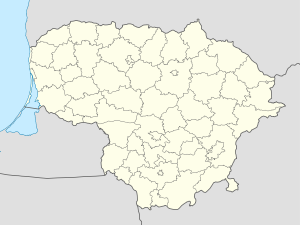 Ariogala Location of Ariogala | |||
| Coordinates: 55°16′0″N 23°28′0″E / 55.26667°N 23.46667°ECoordinates: 55°16′0″N 23°28′0″E / 55.26667°N 23.46667°E | |||
| Country |
| ||
| Ethnographic region | Samogitia | ||
| County |
| ||
| Municipality | Raseiniai district municipality | ||
| Eldership | Ariogala eldership | ||
| Capital of | Ariogala eldership | ||
| First mentioned | 1253 | ||
| Granted city rights | 1792 | ||
| Population (2009) | |||
| • Total | 3,376 | ||
| Time zone | EET (UTC+2) | ||
| • Summer (DST) | EEST (UTC+3) | ||

Ariogala (![]() pronunciation ) is a town in central Lithuania. It is located on the Dubysa River, which flows through the town.
pronunciation ) is a town in central Lithuania. It is located on the Dubysa River, which flows through the town.
Population

Name
Ariogala is the Lithuanian name of the city. Versions of the name in other languages include Polish: Ejragoła, Russian: Эйрагола Eiragola, Belarusian: Эйрагола Eirahola, Yiddish: אייראַגאָלע Eyragole.
History
In 1941 all the Jews from Ariogala and some nearby villages were gathered in a ghetto.[1] At the end of August/beginning of September 1941, around 700 Jewish men, women and children were shot in a field near the village.
References
Notes
- (Lithuanian) Gyventojų skaičius metų pradžioje (Population statistics). Lithuanian Department of Statistics.
- Geographical data. administrative territorial division. Lithuanian Department of Statistics.
| Wikimedia Commons has media related to Ariogala. |

This article is issued from Wikipedia - version of the 11/12/2016. The text is available under the Creative Commons Attribution/Share Alike but additional terms may apply for the media files.