Caher (mountain)
This article is about the mountain in County Kerry. For the hill in County Cork, see Caher Mountain.
| Caher | |
|---|---|
| Cathair na Féinne | |
 Caher from Carrauntoohil | |
| Highest point | |
| Elevation | 1,001 m (3,284 ft) [1] |
| Prominence | 99.7 m (327 ft) [2] |
| Listing | Furth, Hewitt |
| Coordinates | Coordinates: 51°59′41″N 9°45′31″W / 51.9946°N 9.7585°W |
| Naming | |
| Translation | stone fort of the Fianna (Irish) |
| Geography | |
| Parent range | Macgillycuddy's Reeks |
| OSI/OSNI grid | V792839 |
| Topo map | OSI Discovery 78 |
| Climbing | |
| Easiest route | Hike |
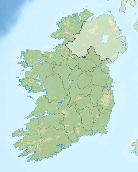
Caher[2] (Irish: Cathair or Cathair na Féinne, meaning "stone fort of the Fianna"),[2] also called Caher East Top,[1] is the third-highest mountain peak in Ireland, at 1,001 metres (3,284 ft).[1] Some sources give its height as 1,000 metres (3,300 ft).[2]
Geography
The mountain lies to the southwest of Carrauntoohil (Ireland's highest peak) in the MacGillycuddy's Reeks of County Kerry. It is classed as a Furth by the Scottish Mountaineering Club[3] and is also in the list of "Irish Munros".[1]
The summit is at grid reference V792838.[2] Its neighbouring peaks are Caher (West Top), The Bones, Carrauntoohil, Curraghmore, Beenkeragh and Skregmore.[1]
See also
References
This article is issued from Wikipedia - version of the 12/6/2015. The text is available under the Creative Commons Attribution/Share Alike but additional terms may apply for the media files.