Georgia State Route 81
| ||||
|---|---|---|---|---|
 | ||||
| Route information | ||||
| Maintained by GDOT | ||||
| Length: | 68.5 mi[1] (110.2 km) | |||
| Major junctions | ||||
| West end: |
| |||
|
| ||||
| North end: |
| |||
| Location | ||||
| Counties: | Henry, Newton, Walton, Barrow | |||
| Highway system | ||||
| ||||

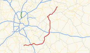
State Route 81 (SR 81) is a 69.0-mile-long (111.0 km) diagonal state highway that runs southwest-to-northeast in the northwestern part of the U.S. state of Georgia. Its route exists within portions of Henry, Newton, Walton, and Barrow counties.
Route description
Western terminus to Oxford
SR 81 begins at an intersection with US 19/US 41/SR 3 (Bear Creek Boulevard), just north of Hampton, in Henry County. It heads east to McDonough. There, it intersects SR 20 (Hampton Road). They run concurrent to the northeast, into the main part of town. Immediately, they have an interchange with Interstate 75 (I-75) at exit 218. Afterward, the two highways intersect US 23/SR 42. A little farther to the east is an intersection with SR 155 (Zack Hinton Parkway). At this intersection, SR 20 splits off to the north. SR 81 then heads to the southeast before curving to the northeast and crosses over the South River, into Newton County. In Henry County, SR 81 is signed as a west–east route; signage changes to south–north at or near the Newton County line. The highway has an intersection with SR 212. Then, it head north before curving to the northeast again. It meets SR 162 just before it enters Porterdale. In town is an intersection with the northern terminus of SR 162 Connector. SR 81 crosses over the Yellow River and passes through the main part of town. Immediately after leaving Porterdale, it enters Covington, where it turn north and intersects US 278/SR 12, before passing under, but not interchanging I-20. Then, it passes through Oxford.[1]
Oxford to Winder

On the northern end of Oxford, the road curves to the north-northeast and meet the northern terminus of SR 142, before turning to the north and entering Walton County. Northward is Walnut Grove, where it intersects SR 138. The route heads north-northwest to Loganville. In town is a brief concurrency with US 78/SR 10 (Atlanta Highway) and splits off to the northwest. In the main part of town is a very brief concurrency with SR 20. Then, it heads northeast, passing through rural areas of the county, before it crosses the Apalachee River into Barrow County. Southwest of Winder is an intersection with US 29/SR 316. Just before entering Winder, the highway passes Fort Yargo State Park on its western end. In Winder, it reaches its northern terminus, an intersection with US 29 Business/SR 8/SR 11/SR 53.[1]
Major intersections
| County | Location | mi[1] | km | Destinations | Notes |
|---|---|---|---|---|---|
| Henry | | 0.0 | 0.0 | Southern terminus | |
| McDonough | 8.4 | 13.5 | Southern end of SR 20 concurrency | ||
| 8.6 | 13.8 | I-75, exit 218 | |||
| 11.3 | 18.2 | Southbound lanes of US 23/SR 42 on one-way pairs | |||
| 11.3 | 18.2 | Northbound lanes of US 23/SR 42 on one-way pairs | |||
| 11.8 | 19.0 | Northern end of SR 20 concurrency | |||
| Newton | | 24.5 | 39.4 | ||
| | 30.4 | 48.9 | |||
| Porterdale | 31.6 | 50.9 | Northern terminus of SR 162 Connector | ||
| Covington | 35.5 | 57.1 | |||
| | 40.2 | 64.7 | Northern terminus of SR 142 | ||
| Walton | Walnut Grove | 45.4 | 73.1 | ||
| Loganville | 52.1 | 83.8 | Southern end of US 78/SR 10 concurrency | ||
| 52.5 | 84.5 | Northern end of US 78/SR 10 concurrency | |||
| 53.2 | 85.6 | Southern end of SR 20 concurrency | |||
| 53.4 | 85.9 | Northern end of SR 20 concurrency | |||
| Barrow | | 64.7 | 104.1 | ||
| Winder | 68.5 | 110.2 | Northern terminus | ||
1.000 mi = 1.609 km; 1.000 km = 0.621 mi
| |||||
See also
-
.svg.png) Georgia (U.S. state) portal
Georgia (U.S. state) portal -
 U.S. Roads portal
References
- 1 2 3 4 Google (July 25, 2013). "Route of SR 81" (Map). Google Maps. Google. Retrieved July 25, 2013.
External links
-
 Media related to Georgia State Route 81 at Wikimedia Commons
 - Georgia Roads (Routes 81 - 100)