Gitit (moshav)
| Gitit גִּתִּית, גיתית | |
|---|---|
 | |
 Gitit | |
| Coordinates: 32°6′3.82″N 35°23′45.59″E / 32.1010611°N 35.3959972°ECoordinates: 32°6′3.82″N 35°23′45.59″E / 32.1010611°N 35.3959972°E | |
| District | Judea and Samaria Area |
| Council | Bik'at HaYarden |
| Region | West Bank |
| Affiliation | Mishkei Herut Beitar |
| Founded | 1972 |
| Founded by | Nahal |
| Population (2015)[1] | 376 |
| Website | www.gittit.co.il |
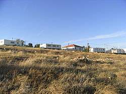
Gitit (Hebrew: גִּתִּית) is a moshav and Israeli settlement in the West Bank.[2] Located in the Jordan Valley with an area of 1,500 dunams (1.5 km2; 0.58 sq mi), it falls under the jurisdiction of Bik'at HaYarden Regional Council.[2] In 2015 it had a population of 376.
The international community considers Israeli settlements in the West Bank illegal under international law, but the Israeli government disputes this.[3]
History
The village was established in 1972 as a Nahal settlement. It is named for a musical instrument mentioned in the Bible with a similar shape as the area:[4] f.e. Psalm 8:1.
In 1975 it became a civilian community affiliated with Herut Beitar.[2] In 1978 it became a moshav shitufi, but later reverted to moshav ovdim status.
References
- ↑ "List of localities, in Alphabetical order" (PDF). Israel Central Bureau of Statistics. Retrieved 16 October 2016.
- 1 2 3 Gitit Bik'at HaYarden Regional Council
- ↑ "The Geneva Convention". BBC News. 10 December 2009. Retrieved 27 November 2010.
- ↑ Bitan, Hanna: 1948-1998: Fifty Years of 'Hityashvut': Atlas of Names of Settlements in Israel, Jerusalem 1999, Carta, p.19, ISBN 965-220-423-4 (Hebrew)
External links
This article is issued from Wikipedia - version of the 8/7/2016. The text is available under the Creative Commons Attribution/Share Alike but additional terms may apply for the media files.