Glounthaune railway station
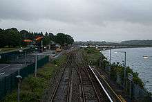
Glounthaune railway station in 2008
Mallow to Youghal/Cóbh | |||||||||||||||||||||||||||||||||||||||||||||||||||||||||||||||||||||||||||||||||||||||||||||||||||||||||||||||||||||||||||||||||||||||||||||||||||||||||||||||||||||
|---|---|---|---|---|---|---|---|---|---|---|---|---|---|---|---|---|---|---|---|---|---|---|---|---|---|---|---|---|---|---|---|---|---|---|---|---|---|---|---|---|---|---|---|---|---|---|---|---|---|---|---|---|---|---|---|---|---|---|---|---|---|---|---|---|---|---|---|---|---|---|---|---|---|---|---|---|---|---|---|---|---|---|---|---|---|---|---|---|---|---|---|---|---|---|---|---|---|---|---|---|---|---|---|---|---|---|---|---|---|---|---|---|---|---|---|---|---|---|---|---|---|---|---|---|---|---|---|---|---|---|---|---|---|---|---|---|---|---|---|---|---|---|---|---|---|---|---|---|---|---|---|---|---|---|---|---|---|---|---|---|---|---|---|---|---|
Legend
| |||||||||||||||||||||||||||||||||||||||||||||||||||||||||||||||||||||||||||||||||||||||||||||||||||||||||||||||||||||||||||||||||||||||||||||||||||||||||||||||||||||
Glounthaune railway station serves the town of Glounthaune in County Cork, Ireland.
It is the junction between the Cobh and Midleton Cork Commuter lines.[1]
The station is unstaffed. Platform 1 (to Midleton/Cobh) is fully accessible, but platform 2 (to Cork) is accessible only via stairs.
Westbound trains toward Cork often leave this station 1 or 2 minutes earlier than scheduled departure time at this station.
This is a frequent commuter station consisting of trains every 15 minutes on peak time weekdays to Cork city and every 30 minutes to Midleton & Cobh.

Cobh Junction in 1973 with the line to Youghal on the left.
References
- ↑ "Printable Timetables". Irish Rail.
External links
| Preceding station | Following station | |||
|---|---|---|---|---|
| Little Island | Commuter Cork-Cobh |
Fota | ||
| Commuter Cork-Midleton |
Carrigtwohill | |||
| Future | ||||
| Little Island | Commuter | Carrigtwohill West | ||
Coordinates: 51°54′40″N 8°19′30″W / 51.9112°N 8.3251°W
This article is issued from Wikipedia - version of the 5/1/2015. The text is available under the Creative Commons Attribution/Share Alike but additional terms may apply for the media files.