Grybaulia
| Grybaulia | |
|---|---|
| Village | |
 Grybaulia Location of Grybaulia | |
| Coordinates: 53°59′58″N 24°21′40″E / 53.99944°N 24.36111°ECoordinates: 53°59′58″N 24°21′40″E / 53.99944°N 24.36111°E | |
| Country |
|
| Ethnographic region | Dzūkija |
| County |
|
| Municipality | Varėna district municipality |
| Eldership | Marcinkonys eldership |
| Population (2001) | |
| • Total | 38 |
| Time zone | EET (UTC+2) |
| • Summer (DST) | EEST (UTC+3) |
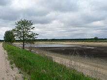
One of the old fish ponds in Grybaulia
Grybaulia is a small village in Dzūkija National Park in Lithuania. The village is best known for its extensive fish ponds, which, surrounded by boreal forests provide breeding, feeding and wintering habitats for a number of bird species.

This article is issued from Wikipedia - version of the 5/22/2015. The text is available under the Creative Commons Attribution/Share Alike but additional terms may apply for the media files.