Jaigad Fort
| Jaigad Fort | |
|---|---|
| जयगड किल्ला | |
| Part of the Maratha Empire | |
| Jaigad, Ratnagiri district, Maharashtra | |
|
Western Wall of the Jaigad Fort | |
 Jaigad Fort | |
| Coordinates | 17°18′03″N 73°13′17″E / 17.3007°N 73.2215°E |
| Type | Coastal Fortification |
| Site information | |
| Controlled by |
Bijapur
|
| Open to the public | Yes |
| Condition | Protected Ruins |
| Site history | |
| Built by | Presumed to be Sultan of Bijapur, strengthened by Kanhoji Angre |
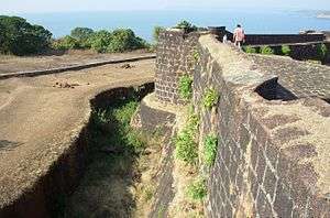
Jaigad Fort (Marathi: जयगड किल्ला, Jayagaḍa killā) (Also transliterated as Zyghur in old British records.[2]) is a coastal fortification that is located at the tip of a peninsula in Ratnagiri District at a distance of 14 km from the temple town of Ganpatipule, in the state of Maharashtra, India. Nestled on a cliff, it overlooks a bay formed where the Shastri river enters the Arabian Sea.[3] It has a commanding view of the bay, the nearby power plant and the open sea. A jetty port Angrey, and a lighthouse is located nearby. Although in ruins, most of the fort's outer wall and ramparts still stand. A deep moat surrounds the fort side not facing the cliff edge. In the middle of the 13 acre fort lies the palace of Kanhoji Angre, a Ganpati temple and wells to store water. It is a protected monument.[4]
References
- ↑ Naravane, M. S. (1998). The Maritime and Coastal Forts of India. Pg. 71: APH Publishing. pp. 196 pages. ISBN 8170249104.
- ↑ Naravane, M. S. (1998). The Maritime and Coastal Forts of India. Pg. 70: APH Publishing. pp. 196 pages. ISBN 8170249104.
- ↑ "India travelogue entry about Ganepatipule and Jaigad Fort". Retrieved 2007-01-15.
- ↑ "List of the protected monuments of Mumbai Circle district-wise" (PDF).