Mount Sundoro
| Mount Sindara | |
|---|---|
 | |
| Highest point | |
| Elevation | 3,136 m (10,289 ft) [1] |
| Listing |
Ultra Ribu |
| Coordinates | 7°18′02.91″S 109°59′46.34″E / 7.3008083°S 109.9962056°ECoordinates: 7°18′02.91″S 109°59′46.34″E / 7.3008083°S 109.9962056°E |
| Geography | |
 Sindoro Location in Java | |
| Location | Java, Indonesia |
| Geology | |
| Mountain type | Stratovolcano |
| Last eruption | October to November 1971 |
| Climbing | |
| Easiest route | Gubugklakah, Burno |
Mount Sindara, Mount Sindoro or Mount Sundoro is an active stratovolcano in Central Java, Indonesia. Parasitic craters and cones are found in the northwest-southern flanks; the largest is called Kembang. A small lava dome occupies the volcano's summit. Historical eruptions have been mostly mild-to-moderate.[1]
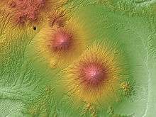
Mount Sundoro (left)
Mount Sumbing (right)
Mount Sumbing (right)
See also
| Wikimedia Commons has media related to Mount Sundoro. |
References
- 1 2 "Sundoro". Global Volcanism Program. Smithsonian Institution. Retrieved 2006-12-26.
This article is issued from Wikipedia - version of the 4/2/2016. The text is available under the Creative Commons Attribution/Share Alike but additional terms may apply for the media files.