Slieve Commedagh
| Slieve Commedagh | |
|---|---|
| Sliabh Coimhéideach | |
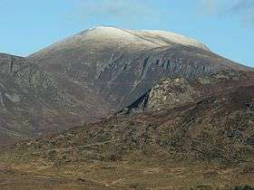 Slieve Commedagh from the south | |
| Highest point | |
| Elevation | 767 m (2,516 ft) [1][2] |
| Prominence | 180 m (590 ft) [1] |
| Listing | Marilyn, Hewitt |
| Coordinates | 54°11′20″N 5°56′19″W / 54.188855°N 5.938667°WCoordinates: 54°11′20″N 5°56′19″W / 54.188855°N 5.938667°W |
| Naming | |
| Translation | mountain of guarding/watching (Irish) |
| Geography | |
| Location | County Down, Northern Ireland |
| Parent range | Mournes |
| OSI/OSNI grid | J346286 |
| Topo map | OSNI Discoverer 29 |
Slieve Commedagh (from Irish: Sliabh Coimhéideach, meaning "mountain of guarding/watching")[3] is a 767 m (2,516 ft) mountain in County Down, Northern Ireland. It is the second-highest of the Mourne Mountains, after Slieve Donard,[1] and the second-highest mountain in Northern Ireland.
Slieve Commedagh lies to the northwest of Slieve Donard, and the two are linked by a col. At the summit of the mountain is a small one-room tower. This stone tower is part of the Mourne Wall, which passes over the mountain.[1]
The Slieve Commedagh massif also includes the peaks of Slievecorragh (to the east), Shan Slieve, Slievenamaddy and Slievenabrock (to the north).
Gallery
 Slieve Commedagh and the Mourne Wall viewed from the top of Slieve Donard
 Slieve Commedagh (middle background) from the south
%2C_February_2010.JPG) Slieve Commedagh (right) viewed from Murlough Beach
Slieve Commedagh (right) viewed from Murlough Beach
See also
References
Mountains and hills of Ulster | ||
|---|---|---|
| Antrim Hills |  | |
| Antrim Plateau | ||
| Belfast Hills | ||
| Croaghgorms | ||
| Derryveagh | ||
| Inishowen | ||
| Mournes | ||
| Sperrins | ||
| Southwest Donegal | ||
| Others | ||
This article is issued from Wikipedia - version of the 2/22/2015. The text is available under the Creative Commons Attribution/Share Alike but additional terms may apply for the media files.