Voorst
For other uses, see Voorst (disambiguation).
| Voorst | |||
|---|---|---|---|
| Municipality | |||
|
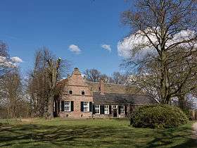
De Vecht | |||
| |||
.svg.png) Location in Gelderland | |||
| Coordinates: 52°14′N 6°7′E / 52.233°N 6.117°ECoordinates: 52°14′N 6°7′E / 52.233°N 6.117°E | |||
| Country | Netherlands | ||
| Province | Gelderland | ||
| Government[1] | |||
| • Body | Municipal council | ||
| • Mayor | Jos Penninx (PvdA) | ||
| Area[2] | |||
| • Total | 126.47 km2 (48.83 sq mi) | ||
| • Land | 123.07 km2 (47.52 sq mi) | ||
| • Water | 3.40 km2 (1.31 sq mi) | ||
| Elevation[3] | 6 m (20 ft) | ||
| Population (May 2014)[4] | |||
| • Total | 23,860 | ||
| • Density | 194/km2 (500/sq mi) | ||
| Demonym(s) | Voorstenaar | ||
| Time zone | CET (UTC+1) | ||
| • Summer (DST) | CEST (UTC+2) | ||
| Postcode | 7382–7397, 7439 | ||
| Area code | 055, 0571 | ||
| Website |
www | ||


Voorst, camping-farm de Adelaar
Voorst (![]() pronunciation ) is a municipality and a town in the eastern Netherlands.
pronunciation ) is a municipality and a town in the eastern Netherlands.
Population centres
- Appen (near a wood where nice walks can be taken)
- Bussloo (with a recreation centre with a small lake and beach)
- De Kar (near a motorway junction (A1, Amsterdam- Berlin)
- De Vecht
- De Wijk
- Gietelo (castle ruin of Nijenbeek on the IJssel dyke)
- Klarenbeek (partly in the municipality Apeldoorn; small railroad station)
- Klein-Amsterdam
- Nijbroek
- Posterenk (also near the A1, with an old Dutch wind-mill)
- Spekhoek
- Steenenkamer, actually an outskirt of Deventer
- Terwolde
- Teuge (with an airfield, where parachuting is taught)
- Twello, half-way between Apeldoorn and Deventer, which is the main village of the municipality, having over 11,000 inhabitants; the town-hall, some industry, most schools, a railway station, a shopping centre etc. can be found there
- Voorst, an old village along the road between Apeldoorn and Zutphen, with a beautiful old church; 1 mile south of Voorst, another small railroad station was opened in 2006
- Wilp, a tiny village on the IJssel opposite to Deventer; it has a small, very old church and a hospital for mentally handicapped people; the village already existed in 768; Saint Lebuinus built a chapel there; the name is allegedly derived from wel-apa that is: well-water; it is possible, that prehistoric Celtic or Germanic people worshipped a holy well there.

Dutch topographic map of the municipality of Voorst, June 2015
References
- ↑ "Burgemeester Jos Penninx" [Mayor Jos Penninx] (in Dutch). Gemeente Voorst. Retrieved 20 July 2014.
- ↑ "Kerncijfers wijken en buurten" [Key figures for neighbourhoods]. CBS Statline (in Dutch). CBS. 2 July 2013. Retrieved 12 March 2014.
- ↑ "Postcodetool for 7391KA". Actueel Hoogtebestand Nederland (in Dutch). Het Waterschapshuis. Retrieved 20 July 2014.
- ↑ "Bevolkingsontwikkeling; regio per maand" [Population growth; regions per month]. CBS Statline (in Dutch). CBS. 26 June 2014. Retrieved 24 July 2014.
External links
 Media related to Voorst, Gelderland at Wikimedia Commons
- Official website
 |
Epe | |
Olst-Wijhe (OV) | |
| Apeldoorn | |
Deventer (OV) Lochem | ||
| ||||
| | ||||
| Brummen | Zutphen |

This article is issued from Wikipedia - version of the 2/4/2016. The text is available under the Creative Commons Attribution/Share Alike but additional terms may apply for the media files.