Höhenland
| Höhenland | |
|---|---|
 Höhenland | |
Location of Höhenland within Märkisch-Oderland district 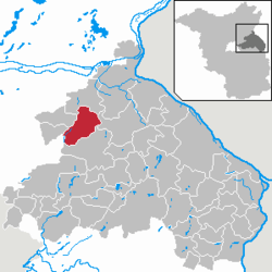 | |
| Coordinates: 52°42′00″N 13°52′59″E / 52.70000°N 13.88306°ECoordinates: 52°42′00″N 13°52′59″E / 52.70000°N 13.88306°E | |
| Country | Germany |
| State | Brandenburg |
| District | Märkisch-Oderland |
| Municipal assoc. | Falkenberg-Höhe |
| Government | |
| • Mayor | Ingolf Schmidt |
| Area | |
| • Total | 53.83 km2 (20.78 sq mi) |
| Population (2015-12-31)[1] | |
| • Total | 1,026 |
| • Density | 19/km2 (49/sq mi) |
| Time zone | CET/CEST (UTC+1/+2) |
| Postal codes | 16259 |
| Dialling codes | 033454 |
| Vehicle registration | MOL |

Church in Leuenberg
Höhenland is a municipality in the district Märkisch-Oderland, in Brandenburg, Germany.
- Wölsickendorf
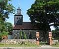 Church
 Manor house
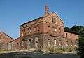 Former Distillery
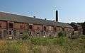 Barnyard
 Traffic sign
References
External links
![]() Media related to Höhenland at Wikimedia Commons
Media related to Höhenland at Wikimedia Commons
This article is issued from Wikipedia - version of the 4/18/2015. The text is available under the Creative Commons Attribution/Share Alike but additional terms may apply for the media files.