Profondeville
| Profondeville | ||
|---|---|---|
| Municipality | ||
|
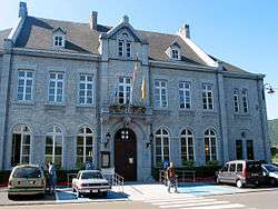
The town hall | ||
| ||
 Profondeville Location in Belgium | ||
|
Location of Profondeville in the province of Namur 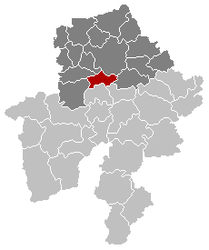 | ||
| Coordinates: 50°23′N 04°52′E / 50.383°N 4.867°ECoordinates: 50°23′N 04°52′E / 50.383°N 4.867°E | ||
| Country | Belgium | |
| Community | French Community | |
| Region | Wallonia | |
| Province | Namur | |
| Arrondissement | Namur | |
| Government | ||
| • Mayor | Jean-Pierre Bailly | |
| • Governing party/ies | IC2006 | |
| Area | ||
| • Total | 50.34 km2 (19.44 sq mi) | |
| Population (1 January 2016)[1] | ||
| • Total | 12,109 | |
| • Density | 240/km2 (620/sq mi) | |
| Postal codes | 5170 | |
| Area codes | 081 | |
| Website | www.profondeville.be | |

Profondeville (French: [pʁɔ.fɔ̃d.vil]) is a Walloon municipality located in the Belgian province of Namur. On January 1, 2016, Profondeville had a total population of 12,117. The total area of the municipality is 50.34 km2 (19.44 sq mi) and the population density is 240.70 inhabitants per km².
In addition to Profondeville itself, the municipality includes the following villages: Arbre, Bois-de-Villers, Lesve, Lustin, Rivière and a part of Floreffe called Lakisse.
Gallery
 Profondeville, church: église Saint-Remy
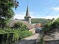 Rivière, church
Twin towns
 Roquebrune-Cap-Martin, France
See also
References
- ↑ Population per municipality as of 1 January 2016 (XLS; 397 KB)
External links
-
 Media related to Profondeville at Wikimedia Commons
 - Official website
 |
Fosses-la-Ville | Floreffe, Namur | | |
| Mettet | |
Assesse | ||
| ||||
| | ||||
| Anhée | Yvoir |
Municipalities in the Province of Namur | ||
|---|---|---|
| Dinant |  | |
| Namur | ||
| Philippeville | ||
This article is issued from Wikipedia - version of the 12/1/2016. The text is available under the Creative Commons Attribution/Share Alike but additional terms may apply for the media files.