| [3] |
Name on the Register[4] |
Image |
Date listed[5] |
Location |
City or town |
Description |
|---|
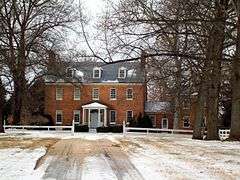
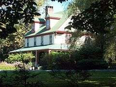
| 1 |
Commodore Joshua Barney House |
Upload image |
000000001978-08-25-0000August 25, 1978
(#78001470) |
North of Savage at 7912 Savage-Guilford Rd.
39°09′17″N 76°49′54″W / 39.154722°N 76.831667°W / 39.154722; -76.831667 (Commodore Joshua Barney House) |
Savage |
|
| 2 |
Bollman Suspension and Trussed Bridge |
|
000000001972-10-18-0000October 18, 1972
(#72000582) |
Spanning the Little Patuxent River near the junction of Gorman Rd. and Foundry St.
39°08′05″N 76°49′31″W / 39.134722°N 76.825278°W / 39.134722; -76.825278 (Bollman Suspension and Trussed Bridge) |
Savage |
|
| 3 |
Brick House on the Pike |
Upload image |
000000001996-01-11-0000January 11, 1996
(#95001522) |
9465 Baltimore National Pike
39°16′45″N 76°50′38″W / 39.279167°N 76.843889°W / 39.279167; -76.843889 (Brick House on the Pike) |
Ellicott City |
|
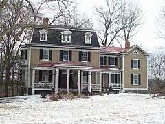
| 4 |
Burleigh |
|
000000001982-11-30-0000November 30, 1982
(#82001596) |
3950 White Rose Way
39°15′45″N 76°52′04″W / 39.262469°N 76.867878°W / 39.262469; -76.867878 (Burleigh) |
Ellicott City |
Also known as Burleigh Manor
|
| 5 |
Carrollton Hall |
|
000000002014-12-16-0000December 16, 2014
(#14001042) |
12280 Folly Quarter Rd.
39°15′22″N 76°56′14″W / 39.2561°N 76.9373°W / 39.2561; -76.9373 (Carrollton Hall) |
Ellicott City |
Now the Shrine of St. Anthony.
|
| 6 |
Cherry Grove, HO-1 |
|
000000002007-06-21-0000June 21, 2007
(#07000567) |
2937 Jennings Chapel Rd.
39°17′39″N 77°05′38″W / 39.294272°N 77.093813°W / 39.294272; -77.093813 (Cherry Grove, HO-1) |
Woodbine |
|
| 7 |
Christ Church Guilford |
|
000000001978-01-30-0000January 30, 1978
(#78001469) |
North of Guilford at 6800 Oakland Mills Rd.
39°11′04″N 76°49′41″W / 39.184444°N 76.828056°W / 39.184444; -76.828056 (Christ Church Guilford) |
Columbia |
|
| 8 |
Curtis-Shipley Farmstead |
|
000000002006-12-12-0000December 12, 2006
(#06001127) |
5771 Waterloo Rd.
39°12′53″N 76°48′03″W / 39.214722°N 76.800833°W / 39.214722; -76.800833 (Curtis-Shipley Farmstead) |
Ellicott City |
|
| 9 |
Daniels Mill |
|
000000001973-04-11-0000April 11, 1973
(#73000929) |
Daniels Rd.
39°19′02″N 76°48′47″W / 39.317222°N 76.813056°W / 39.317222; -76.813056 (Daniels Mill) |
Daniels |
|
| 10 |
Dorsey Hall |
|
000000002001-12-28-0000December 28, 2001
(#01001374) |
5100 Dorsey Hall Dr.
39°14′43″N 76°50′05″W / 39.245278°N 76.834722°W / 39.245278; -76.834722 (Dorsey Hall) |
Columbia |
|
| 11 |
Doughoregan Manor |
|
000000001971-11-11-0000November 11, 1971
(#71000376) |
8 miles west of Ellicott City on Manor Lane
39°16′37″N 76°53′25″W / 39.276944°N 76.890278°W / 39.276944; -76.890278 (Doughoregan Manor) |
Ellicott City |
|
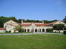
| 12 |
Elkridge Furnace Complex |
|
000000001990-06-28-0000June 28, 1990
(#90000635) |
5730 and 5741-5745 Furnace Ave., 5735 Race Rd.
39°12′47″N 76°42′12″W / 39.213056°N 76.703333°W / 39.213056; -76.703333 (Elkridge Furnace Complex) |
Elkridge |
|
| 13 |
Ellicott City Historic District |
|
000000001978-07-31-0000July 31, 1978
(#78001467) |
Maryland Route 144
39°16′11″N 76°48′00″W / 39.269722°N 76.8°W / 39.269722; -76.8 (Ellicott City Historic District) |
Ellicott City |
|
| 14 |
Ellicott City Station |
|
000000001968-11-24-0000November 24, 1968
(#68000025) |
South of the Patapsco River Bridge
39°16′02″N 76°47′43″W / 39.267222°N 76.795278°W / 39.267222; -76.795278 (Ellicott City Station) |
Ellicott City |
|
| 15 |
Elmonte |
|
000000001978-08-25-0000August 25, 1978
(#78001468) |
9095 Furrow Avenue
39°18′28″N 76°49′25″W / 39.307778°N 76.823611°W / 39.307778; -76.823611 (Elmonte) |
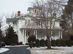
Ellicott City |
|
| 16 |
Enniscorthy |
|
000000001986-05-08-0000May 8, 1986
(#86001019) |
3412 Folly Quarter Rd.
39°16′42″N 76°54′12″W / 39.278333°N 76.903333°W / 39.278333; -76.903333 (Enniscorthy) |
Ellicott City |
|
| 17 |
Glenelg Manor |
|
000000001983-02-03-0000February 3, 1983
(#83002952) |
Southeast of Glenelg at 12793 Folly Quarter Road
39°15′06″N 76°57′41″W / 39.251667°N 76.961389°W / 39.251667; -76.961389 (Glenelg Manor) |
Glenelg |
|
| 18 |
Hobson's Choice |
Upload image |
000000001984-09-13-0000September 13, 1984
(#84001802) |
3145 Florence Rd.
39°18′24″N 77°05′32″W / 39.306667°N 77.092222°W / 39.306667; -77.092222 (Hobson's Choice) |
Woodbine |
|
| 19 |
Howard Lodge |
Upload image |
000000002012-10-09-0000October 9, 2012
(#12000845) |
12301 Howard Lodge Rd.
39°20′14″N 76°56′23″W / 39.337202°N 76.939831°W / 39.337202; -76.939831 (Howard Lodge) |
Sykesville vicinity |
|
| 20 |
The Lawn |
Upload image |
000000001984-10-29-0000October 29, 1984
(#84000412) |
6036 Old Lawyers Hill Rd.
39°13′16″N 76°43′09″W / 39.221111°N 76.719167°W / 39.221111; -76.719167 (The Lawn) |
Elkridge |
|
| 21 |
Lawyers Hill Historic District |
|
000000001993-09-23-0000September 23, 1993
(#93001000) |
Area surrounding Lawyers Hill and Old Lawyers Hill Rds. and Elibank Dr.
39°13′12″N 76°43′53″W / 39.22°N 76.731389°W / 39.22; -76.731389 (Lawyers Hill Historic District) |
Elkridge |
|
| 22 |
Linnwood |
|
000000002006-12-12-0000December 12, 2006
(#06001126) |
2327 Daniels Rd.
39°18′27″N 76°48′23″W / 39.3075°N 76.806389°W / 39.3075; -76.806389 (Linnwood) |
Ellicott City |
|
| 23 |
MacAlpine |
|
000000002004-12-23-0000December 23, 2004
(#04001382) |
3621 Macalpine Rd.
39°16′15″N 76°49′46″W / 39.270763°N 76.829497°W / 39.270763; -76.829497 (MacAlpine) |
Ellicott City |
|
| 24 |
Montrose |
|
000000002000-12-13-0000December 13, 2000
(#00001506) |
13370 Brighton Dam Rd.
39°12′04″N 76°58′39″W / 39.201111°N 76.9775°W / 39.201111; -76.9775 (Montrose) |
Clarksville |
|
| 25 |
Oakdale |
Upload image |
000000002014-12-16-0000December 16, 2014
(#14001041) |
16449 Ed Warfield Rd.
39°17′19″N 77°04′56″W / 39.2886°N 77.0822°W / 39.2886; -77.0822 (Oakdale) |
Woodbine |
|
| 26 |
Oakland Mills Blacksmith House and Shop |
|
000000002011-11-18-0000November 18, 2011
(#11000820) |
5471 Old Columbia Pike
39°13′17″N 76°50′51″W / 39.221403°N 76.847579°W / 39.221403; -76.847579 (Oakland Mills Blacksmith House and Shop) |
Columbia |
|
| 27 |
Old National Pike Milestones |
|
000000001975-11-27-0000November 27, 1975
(#75002107) |
U.S. Route 40, Alternate U.S. Route 40, and Scenic U.S. Route 40, and Maryland Routes 44 and 165
39°25′13″N 77°16′01″W / 39.420278°N 77.266944°W / 39.420278; -77.266944 (Old National Pike Milestones) |
Lisbon |
|
| 28 |
Patterson Viaduct Ruins |
|
000000001976-06-03-0000June 3, 1976
(#76002221) |
South of Catonsville at the Patapsco River
39°15′00″N 76°45′51″W / 39.25°N 76.764167°W / 39.25; -76.764167 (Patterson Viaduct Ruins) |
Ilchester |
|
| 29 |
Richland Farm |
|
000000002008-03-26-0000March 26, 2008
(#08000217) |
4730 Sheppard Ln.
39°14′40″N 76°56′45″W / 39.244444°N 76.945833°W / 39.244444; -76.945833 (Richland Farm) |
Clarksville |
|
| 30 |
Roberts Inn |
|
000000002006-08-02-0000August 2, 2006
(#06000661) |
14610 Frederick Rd.
39°19′27″N 77°01′12″W / 39.324167°N 77.02°W / 39.324167; -77.02 (Roberts Inn) |
Cooksville |
|
| 31 |
Round About Hills |
|
000000002008-11-20-0000November 20, 2008
(#08001072) |
15505 Cattail Oaks
39°16′00″N 77°02′10″W / 39.266667°N 77.036111°W / 39.266667; -77.036111 (Round About Hills) |
Glenwood |
|
| 32 |
Savage Mill |
|
000000001974-04-18-0000April 18, 1974
(#74002251) |
Southwestern corner of Foundry Rd. and Washington St.
39°08′07″N 76°49′37″W / 39.135278°N 76.826944°W / 39.135278; -76.826944 (Savage Mill) |
Savage |
|
| 33 |
Savage Mill Historic District |
|
000000001975-02-20-0000February 20, 1975
(#75000905) |
North of the Little Patuxent River off U.S. Route 1
39°08′12″N 76°49′38″W / 39.136667°N 76.827222°W / 39.136667; -76.827222 (Savage Mill Historic District) |
Savage |
|
| 34 |
Temora |
|
000000001976-04-30-0000April 30, 1976
(#76001003) |
4252 Columbia Rd.
39°15′14″N 76°49′28″W / 39.253889°N 76.824444°W / 39.253889; -76.824444 (Temora) |
Ellicott City |
|
| 35 |
Thomas Viaduct, Baltimore & Ohio Railroad |
|
000000001966-10-15-0000October 15, 1966
(#66000388) |
Over the Patapsco River between Relay and Elkridge
39°13′19″N 76°42′49″W / 39.221944°N 76.713611°W / 39.221944; -76.713611 (Thomas Viaduct, Baltimore & Ohio Railroad) |
Relay |
|
| 36 |
Trinity Church |
|
000000001974-05-06-0000May 6, 1974
(#74000957) |
7474 Washington Boulevard
39°10′48″N 76°46′13″W / 39.18°N 76.770278°W / 39.18; -76.770278 (Trinity Church) |
Elkridge |
|
| 37 |
Troy |
Upload image |
000000001979-06-22-0000June 22, 1979
(#79001137) |
Interstate 95 and Maryland Route 176 (6500 Mansion Lane)
39°11′44″N 76°45′42″W / 39.195556°N 76.761667°W / 39.195556; -76.761667 (Troy) |
Elkridge |
|
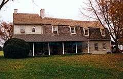
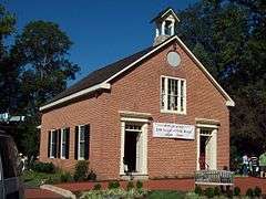
| 38 |
Union Chapel |
|
000000001975-03-17-0000March 17, 1975
(#75000904) |
1 mile north of Glenwood on Maryland Route 97
39°17′45″N 77°01′31″W / 39.295833°N 77.025278°W / 39.295833; -77.025278 (Union Chapel) |
Glenwood |
|
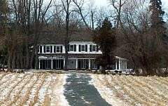
| 39 |
Waverley |
|
000000001974-10-18-0000October 18, 1974
(#74000958) |
2335 Marriottsville Road
39°18′06″N 76°53′55″W / 39.301667°N 76.898611°W / 39.301667; -76.898611 (Waverley) |
Marriottsville |
|
| 40 |
White Hall |
|
000000001977-08-12-0000August 12, 1977
(#77000698) |
West of Ellicott City at 4130 Chatham Rd.
39°15′29″N 76°50′12″W / 39.258056°N 76.836667°W / 39.258056; -76.836667 (White Hall) |
Ellicott City |
|
| 41 |
Woodlawn |
|
000000001983-02-03-0000February 3, 1983
(#83002953) |
9254 Old Annapolis Rd.
39°14′05″N 76°49′33″W / 39.234722°N 76.825833°W / 39.234722; -76.825833 (Woodlawn) |
Columbia |
|