Meyras
| Meyras | ||
|---|---|---|
|
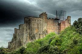
Chateau of Ventadour | ||
| ||
 Meyras | ||
|
Location within Auvergne-Rhône-Alpes region  Meyras | ||
| Coordinates: 44°40′57″N 4°16′05″E / 44.6825°N 4.2681°ECoordinates: 44°40′57″N 4°16′05″E / 44.6825°N 4.2681°E | ||
| Country | France | |
| Region | Auvergne-Rhône-Alpes | |
| Department | Ardèche | |
| Arrondissement | Largentière | |
| Canton | Thueyts | |
| Government | ||
| • Mayor (2008–2014) | Gérard Bruchet | |
| Area1 | 12.31 km2 (4.75 sq mi) | |
| Population (2008)2 | 832 | |
| • Density | 68/km2 (180/sq mi) | |
| Time zone | CET (UTC+1) | |
| • Summer (DST) | CEST (UTC+2) | |
| INSEE/Postal code | 07156 / 07380 | |
| Elevation |
298–880 m (978–2,887 ft) (avg. 370 m or 1,210 ft) | |
|
1 French Land Register data, which excludes lakes, ponds, glaciers > 1 km² (0.386 sq mi or 247 acres) and river estuaries. 2 Population without double counting: residents of multiple communes (e.g., students and military personnel) only counted once. | ||
.svg.png)
Meyras is a commune in the Ardèche department in southern France.
Geography
The river Lignon forms part of the commune's southeastern border, then joins the Ardèche, which flows east through the commune.
Population
| Historical population | ||
|---|---|---|
| Year | Pop. | ±% |
| 1962 | 683 | — |
| 1968 | 798 | +16.8% |
| 1975 | 764 | −4.3% |
| 1982 | 713 | −6.7% |
| 1990 | 729 | +2.2% |
| 1999 | 775 | +6.3% |
| 2008 | 832 | +7.4% |
See also
References
| Wikimedia Commons has media related to Meyras. |
This article is issued from Wikipedia - version of the 10/28/2016. The text is available under the Creative Commons Attribution/Share Alike but additional terms may apply for the media files.